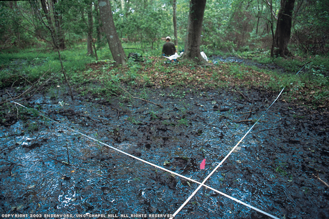
Anyone particularly sensitive to poison ivy?" Carolina ecologist Robert Peet wondered idly as he dropped his backpack. We were on the Currituck Banks in June in a dense shrub thicket dominated by northern bayberry (Myrica pensylvanica) and laced together by an alarming abundance of poison ivy (Toxicodendron radicans). I was already flicking ticks off my shirt sleeve. A pack of dark clouds raced overhead. Surely this toxic plant community about to be doused with rain wasn't our destination, or was it?
While the other volunteer and I recorded the species and numbers of the shrubs and trees on the site, Peet bent to his task of recording the groundcover composition. He worked fast, interrupted only once by an emergency tick-ectomy. "Where's the duct tape?" he shouted at one point, running from a dense thicket in one corner of the plot, his pants covered with dozens of ticks. "Got into a nest of them," he said, ripping off a length of tape and applying the sticky side to remove the ticks. For the rest of the afternoon we checked each other periodically for crawling vermin.
Although the CVS protocol seems to be a model of objectivity, there's actually a great deal of subjectivity in working with and identifying plant communities, admitted Tom Wentworth, a codirector of the CVS along with Peet. "Communities don't really exist in nature. They are human constructs, and we're imposing them on the natural world, which is much more continuous." Deciding where one plant community begins and ends can be somewhat arbitrary.
To illustrate: the Carolina Vegetation Survey so far recognizes thirty-five different longleaf pine communities in North Carolina, but the U.S. National Vegetation Classification recognizes twenty-seven different longleaf pine communities in the entire Southeast. The difference is based mostly on whether the scientists doing the classifications are "splitters" or "lumpers" — lumpers tend to overlook modest variations among similar landscape types, whereas splitters are hesitant to lose the differences.
"When we get into an area and start looking at it carefully, it's not surprising that we want to modify an older classification, usually in the realm of either splitting existing types more finely, or even adding types," explained Wentworth.
Peet, Wentworth, and the other vegetation scientists would later enter the data that we collected that day into the CVS database, joining data from nearly 5,000 plots that they have recorded over the past sixteen years. They collect soil samples from the site and take digital photos as well. Other data include precise location (based on Global Positioning System coordinates) and elevation. The GPS coordinates will enable future researchers to return to a site, find the stakes that have been left as permanent markers, and monitor the changes that have taken place.
When Peet began the Carolina Vegetation Survey, he realized that it would take time — there are more than 4,000 plant species in North Carolina alone. Even more critical than time, perhaps, was the need for highly trained vegetation scientists who could gather the data accurately. That need alone has prevented other Southeastern states from attempting the kind of work that CVS is doing, but in North Carolina that was less of a problem.
"Some fifteen years ago a new faculty member, Peter White, arrived," Peet said. White is the current director of the UNC-Chapel Hill Botanical Garden. "We said, 'Hey, there's a lot of us in the area who are interested in plant communities.'" The founding members of the group included Peet, White, Norman Christensen of the Nicholas School of the Environment at Duke University, Thomas Wentworth of N.C. State, Alan Weakley and Michael Schafale, who were both with the N.C. Natural Heritage Program at the time, and Rob Sutter of The Nature Conservancy. With just a smidgen of flamboyance, Peet and his colleagues dubbed themselves "The Gang of Seven."
"We all wanted to understand pattern on the landscape, and we all wanted to help shape the conservation agenda for the state," Peet said. "So we decided we'd go out and sample a chunk of the landscape for a few summers and see how it worked."
The few summers have stretched to sixteen years, the gang has shrunk to four — making it the "Gang of Only Four" or GOOF — and there's no end in sight. Peet has figured they need another ten or fifteen years to complete the project and produce a series of volumes describing the plant communities of the Carolinas in detail.
It was. The three of us — Peet, another volunteer, and I — were one of six teams that had dispersed that day across the Northern Outer Banks, examining sites at Jockeys Ridge, Southern Shores, and the Currituck National Wildlife Refuge, among other places. Each team was made up of a few volunteers and an experienced botanist who functioned as the team leader. All of the teams were part of an ambitious and grueling multi-year undertaking called the Carolina Vegetation Survey (CVS), a collaborative effort to describe, classify, and inventory the natural vegetation of the state.
For the past sixteen years, a core of trained vegetation scientists, with a supporting cast of volunteers, have spent a couple of weeks every summer counting the herbaceous plants, grasses, shrubs, and trees in measured plots across the state. The project's goal is to a
umulate data to help understand the state's vegetation patterns, guide development away from the rarest jewels, and provide the baseline knowledge needed to protect and restore degraded ecosystems.
For many of us, the natural landscape of North Carolina is an undifferentiated wall of green made up of hundreds of plant species we cannot name. Surprisingly, vegetation scientists are often challenged by the same wall, although their questions have less to do with individual plants than with the larger communities in which they occur. For these ecologists, a plant community is as much a biological entity as a plant species, and teasing out the differences between plant communities is as important as telling one plant species from another. Both species and communities need names. Naming communities is essential for an understanding of where rare plants are found and whether they need conservation protection, questions that in fast-growing North Carolina have a certain urgency.
A plant community without a name, explained Peet, is "sort of like a museum specimen without a label."
Evidently our plot, so rich in poison ivy and ticks, didn't have a label, which was why Peet has chosen this particular spot to do a survey. Judging by the predominance of bayberry, it might be a "maritime wet grassland," or perhaps not. He won't know what to call it until he's finished identifying what grows here and has compared the plot with others recorded along the Carolina coast.
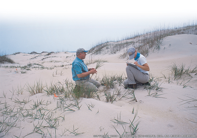
We got to work. We had already surveyed a sparsely vegetated coastal dune grassland earlier that day, so we knew the drill, or, more accurately, what Peet and his colleagues call a "protocol," an exacting method of recording details of plant composition and structure. A standard methodology is necessary so that recorded data are comparable no matter who is doing the recording and in what plant communities they are doing it. It has to be flexible and not too cumbersome, so that the group can move relatively quickly across the state.
Peet staked a fifty-meter tape measure at both ends. We pushed other stakes into the soft earth at ten-meter intervals and ran two shorter tape measures twenty meters apart and perpendicular to the first two. By flagging the outer boundary lines at ten-meter intervals, we had quickly created a 1,000-square-meter plot (fifty meters by twenty meters) divided into ten subplots or "modules."
Over the next several hours, we would do an intensive census of four of the ten modules, recording the species and their occurrences where possible. We would lug unidentified plants in plastic bags back to the base in Manteo where, that evening, the scientists would key out their identities using standard references and even microscopes. The CVS protocol is unique because it enables workers to document species composition and structure at six different spatial scales, ranging from a hundredth of a square meter to a thousand square meters.
"Part of the reason we want this information is our interest in knowing the structure of the vegetation — the plants that occur together and their interactions," Peet said. "Another part is that there isn't one correct spatial scale to characterize what is there. If you would like to look at how the environment correlates with species composition, you'd get a different answer depending on which spatial scale you looked at."
In mountain soils, for example, the abundance of certain nutrients such as calcium and manganese can predict the kinds of plants that will grow there, at least at larger scales of, say, ten meters by ten meters. It is not predictive at scales of less than a meter, however. At those smaller scales, other factors become more important in predicting what will grow, such as whether the plant is on a slope and whether the slope faces north or south.
Because of the different backgrounds of the survey founders, Peet acknowledged there are multiple uses for the information gathered by these inventories. As a university researcher, Peet's interest is mainly in gaining knowledge. "I came into it from the perspective of an academic who simply wants to understand the pattern of vegetation on the landscape," he said. For Alan Weakley, today the curator of the UNC-Chapel Hill Herbarium, conservation is an equally important goal.
"Once we know what these community types are, we compare how much there used to be to what exists now. We also want to know what condition they're in and locate the best examples so we can conserve them," Weakley said. Where certain community types have virtually disappeared — such as longleaf pine, which has declined by about 98 percent throughout the Southeast — the survey data can help restore the ecosystem.
Though the project has not yet been completed, state and federal agencies have increasingly used the growing database to solve problems associated with managing land. U.S. Forest Service managers, for example, have used CVS plot data in constructing or relocating logging roads so that they avoid harming a rare population of an endangered plant. By reviewing the data from a thousand CVS plots in the mountains, they can put together a species profile or model of the plant, discovering, perhaps, that it occurs only in rich cove forests under 2,500 feet and in a certain kind of soil found only in Macon, Transylvania, and Jackson counties. "That makes Forest Service surveys of rare species more targeted and effective, and also more efficient," Weakley said.
The data not only help agencies avoid problems, Weakley added, but can aid "affirmative management," making it easier for foresters to understand the rarity of a particular habitat so they can make decisions to protect it.
The values of pure scientific research may drive Peet, but he feels a sense of loss over the degradation and even destruction of many plant communities. Coastal development has destroyed many of the maritime forests he sampled years ago, while fire suppression has left species-rich longleaf pine communities in overgrown thickets.
As a result, Peet and his colleagues feel that time is running out on their work. More and more, they are addressing the most critical holes in their database to get a snapshot of the biological diversity of the state before development pressures compromise it further. That's the main reason CVS participants chose to study the northern Outer Banks during one session this summer, and the Piedmont prairies, forests, and woodlands around Charlotte and Rock Hill, South Carolina, during the other. In recent years, the group has extended its investigations into South Carolina — a bit of "scope creep," as Weakley describes it.
For all of the scientists and volunteers, the Carolina Vegetation Survey has been a voyage of discovery. A goldenrod species last seen in 1894 has been located again, but perhaps more important, the survey has led to a better understanding of the state's biological diversity — a new understanding of the variety of longleaf pine communities, for example, and a growing appreciation for the Piedmont, long dismissed by scientists and the general public as highly disturbed and even boring.
And while the scientists themselves have profited from the survey, the experience has been equally educational for the volunteers, many of them students. Since the survey began, more than 500 volunteers have spent from a day to an entire week learning to identify plants and read a landscape. They have seen a community of scientists working together as a collaboration of equals.
"One of the exciting things about these yearly events is that you get together with all these people with fragmentary information," says Peet, "but collectively you learn a lot by going out with them and looking at the landscape through their eyes."
A former editor of Wildlife in North Carolina, Lawrence S. Earley is a freelance writer from Raleigh.